Athens Condemns Turkey’s New Marine Parks as “Unilateral and Illegal”
Πηγή Φωτογραφίας: screenshot//Athens Condemns Turkey’s New Marine Parks as “Unilateral and Illegal”
Greece has sharply condemned Turkey’s recent announcement of two marine protected areas in the Aegean and Eastern Mediterranean, accusing Ankara of violating international law and infringing on Greek sovereign rights.
In a strongly worded statement, the Greek Ministry of Foreign Affairs labelled Turkey’s move as a “unacceptable, unilateral and illegal act that produces no legal effect against Greece’s sovereign rights.” The Turkish announcement, submitted to UNESCO, outlines the establishment of marine parks in areas not recognized as Turkish territorial waters.
According to the Greek government, these proposed Turkish marine parks overlap with international waters and are based on Ankara’s long-standing maritime claims, including its controversial “Blue Homeland” doctrine. The move comes shortly after Greece declared its own marine protected area in the Southeastern Cyclades, prompting a swift response from Turkey.
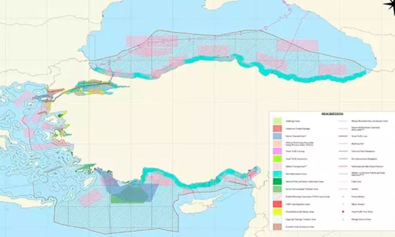
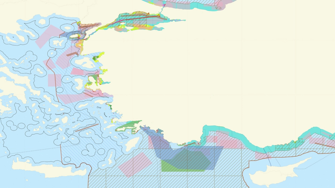
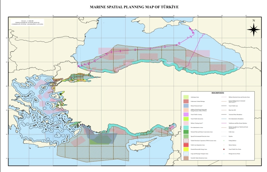
The two Turkish-designated areas are situated in the Northern Aegean—between Lemnos and Samothrace—and around the Kastellorizo-Rhodes axis in the Eastern Mediterranean. These regions have historically been flashpoints in Greek-Turkish maritime disputes, particularly regarding continental shelf rights and Exclusive Economic Zones (EEZs).
“Turkey once again demonstrates complete disregard for the Law of the Sea,” said the Greek Foreign Ministry, asserting that the islands’ rights to maritime zones are being deliberately ignored.
Of particular concern is Turkey’s depiction of the Kastellorizo complex, which appears excluded from maritime delineations on the submitted maps. Greek officials claim this aims to minimize the island’s legal influence in future maritime boundary discussions—an approach consistent with Turkey’s position that Greek islands should have limited EEZ rights.
The new Turkish maps, while avoiding overt provocations such as “grey zones,” continue to reflect Ankara’s expansive maritime claims, echoing past tensions linked to the 2019 Turkey-Libya maritime deal submitted to the UN. Turkish sources told Anadolu Agency that the country plans to increase the number of such protected areas across its seas, citing environmental cooperation as justification.
Greek officials argue that such gestures undermine regional stability and bilateral relations. “Reflexive moves devoid of legal grounding jeopardize good neighbourly relations,” the statement concluded.
Turkey’s Marine Parks: Eco-Camouflage or Maritime Strategy?
Ankara’s latest move to establish marine protected areas in contested zones of the Aegean and Eastern Mediterranean is stirring fresh diplomatic tensions, raising alarms in Athens and concerns in Brussels.
Framed as an environmental initiative, Turkey’s submission to UNESCO of updated maritime spatial planning maps—showcasing newly designated “marine parks”—has a far more strategic undertone. The maps appear to reinforce the controversial Mavi Vatan (“Blue Homeland”) maritime doctrine, which Ankara has increasingly used as a blueprint for projecting influence in semi-enclosed seas.
But Greece isn’t buying the eco-branding.
For Athens, this is just the latest step in a calculated Turkish effort to assert de facto control over key maritime zones by embedding geopolitical claims within environmental frameworks. The Greek Foreign Ministry has condemned the action as a “unilateral and illegal act,” stressing that Turkey’s declared parks lie in non-delimited maritime areas beyond its territorial waters.
The significance? The contested regions—particularly between Lemnos and Samothrace, and around Kastellorizo and Rhodes—are hotspots of unresolved maritime boundaries. Turkey’s decision to draw maritime park borders that ignore the presence and legal maritime effect of Greek islands is not just provocative; it’s deliberate.
This isn’t the first time Ankara has tested boundaries in the name of sustainability. Much like its use of seismic research vessels in disputed waters in 2020, Turkey appears to be using international institutions and soft-power narratives to harden its geopolitical footprint—what analysts call “lawfare via cartography.”
The Kastellorizo issue is emblematic. On Turkish maps, the island appears isolated, with no surrounding maritime delineation, implying it lacks legal bearing in determining EEZs. This mirrors Turkey’s long-held stance that small Greek islands cannot generate extensive maritime zones—an argument rejected by the UN Convention on the Law of the Sea (UNCLOS), to which Turkey is notably not a signatory.
Furthermore, the maps reflect Turkey’s alignment with the contentious Turkey-Libya maritime deal of 2019, which ignores Greek island chains and overlaps with areas claimed by Athens as part of its continental shelf.
Despite avoiding direct mention of “grey zones,” Turkey’s approach constitutes a soft assertion of sovereignty, gradually shifting facts on the ground—or in this case, at sea. The risk for the EU and NATO? That Ankara is crafting a new status quo through attrition, not confrontation.
Bottom line: The marine park designation may sound green, but the message beneath the surface is unmistakably blue—and strategic. How Brussels, Washington, and international bodies respond may determine whether this latest cartographic gambit remains symbolic or becomes precedent-setting.
Source: pagenews.gr
Διαβάστε όλες τις τελευταίες Ειδήσεις από την Ελλάδα και τον Κόσμο


Το σχόλιο σας