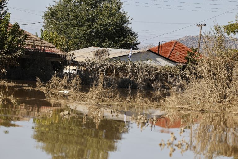
Greece’s central highway is closed due to flooding

Πηγή Φωτογραφίας: Eurokinissi (Αρχείου), Panoramic images of the national road Athens-Thessaloniki and the provincial road Larissa-Sikouri, flooded after a natural disaster
Panoramic images of the national road Athens-Thessaloniki and the provincial road Larissa-Sikouri, flooded after a natural disaster
The traffic ban on sections of the Athens-Thessaloniki national road has caused huge problems in transport and movement, as the swollen Pinios River has turned the country’s main road into a huge lake, and the bypass road adds several hours to travel time.
And the main question that worries many now is when the Athens-Thessaloniki highway will be opened…
According to Christos Karavitis, dean of the Agricultural University of Athens and professor of water resources management, the only way out for all this water accumulated in Pinios is to drain the water to the sea. In particular, he compares Thessaly to a closed basin, the only outlet of which into the Aegean Sea is the Tempi Valley. “This is where the problems begin, because we realize that we are dealing with flat land, without slopes. Therefore, the water moves at a very low speed. When combined with a large amount of water, it spreads out and thus the phenomenon of flooding occurs. The only way to remove all this water is the “outlet” into the sea. To make it even clearer, imagine a bottle of water. We have a wide place and a narrow neck. In order to drain the entire volume of water at the outlet, it is necessary to raise the water level. As of Monday , September 11, we are at the stage where the largest amount of water is already beginning to accumulate in the river bed to flow into the sea.There are already reports that the water level has exceeded 15 meters at the Tempe Bridge. We are dealing with low-lying land, without slopes. Therefore, water moves at a very low speed. When combined with a large amount of water, it spreads out, which creates the phenomenon of flooding.”.
Answering the question of how many days it will take for the water level to decrease, Mr. Karavitis explained that the first calculations showed that about 8-12 days will pass from the end of the phenomenon. “So we’re now estimating about another 5-7 days. If we had a system with sensors at our disposal, we could get specific measurements that would allow us to calculate the exact speed.”
Costas Voudouris, professor of hydrogeology at Aristotle University of Thessaloniki, notes the difficulty of making an accurate forecast and explains why it is impossible to speed up the process.“We cannot answer for sure when the water will be drained from the territory. It depends on the soil, material and their condition. Therefore, this is a natural process that will not occur evenly, i.e. there will not be the same speed in all flooded areas. The basin is huge “We can’t use pumps like we have in the basement of our house to remove the water.”
After communication between journalists from the publication Kathimerini and employees of the Aegean Highway, information was received that pumping out water is also not considered, according to them, as a realistic scenario: “Even if we try to pump out the water, it will come back because the entire area on both sides of the highway is flooded. The only way to open the highway is to lower the water level. Unfortunately, we cannot know when this will happen, any forecasts are uncertain. Right now the water level “is 80 centimeters. But once the water leaves the highway, it will take 1-2 days to carry out a technical inspection along the entire length of the road and make sure that it is safe for drivers.”
Mr Boudouris said the quickest way to open up the closure to traffic more quickly would be to install drainage ditches on the side of the road to drain the water. “In general, holistic projects must be implemented starting from the higher ground. It is a mistake to wait until the water reaches the plains and large cities. It is now clear that these intense events are occurring with greater frequency than in the past. Therefore, we must act accordingly.
The upper level of urban water rise is currently based on the maximum flood that has occurred in the last 50 years. But the flood we experienced in Thessaly is, by some estimates, considered the greatest in 300 years, and by others in 1,000 years.”
As Mr. Karavitis explained, the upper level of water rise in urban areas is currently determined based on the maximum flood of the last 50 years. “But the flood that we experienced in Thessaly, according to some estimates, is considered the maximum in 300 years, and according to others – in 1000 years. As you understand, we, of course, do not have such old data on the amount of precipitation, so we proceed from statistical data. Therefore, we need to invest in modern technologies that will protect us from future disasters.”
Διαβάστε όλες τις τελευταίες Ειδήσεις από την Ελλάδα και τον Κόσμο


Το σχόλιο σας