Greece Issues NAVTEX for Chevron–HELLENiQ Energy Surveys Across 14,000 Sq Km South of Peloponnese
 ΧΡΟΝΟΣ ΑΝΑΓΝΩΣΗΣ 11 '
Πηγή Φωτογραφίας: AP Photo//Greece Issues NAVTEX for Chevron–HELLENiQ Energy Surveys Across 14,000 Sq Km South of Peloponnese



Greece is moving forward with two major offshore research programmes, one focused on potential hydrocarbon resources south of the Peloponnese and the other on preparations for the electricity interconnection of the Dodecanese islands.
The Hellenic Navy Hydrographic Service has issued a NAVTEX for seismic surveys in the southern Ionian Sea and the Kythira Sea, with operations scheduled to continue until January 7, 2027.
The research concerns offshore concession areas associated with the Chevron–HELLENiQ Energy consortium.
At the same time, a separate maritime notice covers geophysical investigations in the southern Aegean for the Corinth–Kos electricity interconnection, a major component of Greece’s plans to connect the Dodecanese islands to the mainland electricity grid.
Although the two projects serve different purposes, both involve extensive offshore operations and reflect the growing importance of Greece’s maritime areas in national energy planning.
One programme aims to assess the potential for future hydrocarbon discoveries. The other is preparing the seabed for critical electricity infrastructure.
NAVTEX Issued: Seismic Surveys Scheduled Until January 7
The navigation warning was issued on November 18, 2026, under reference IRAKLEIO RADIO NAVWARN 1464/26.
It identifies the survey area, the participating vessels and the safety requirements for maritime traffic.
The official notice states:
“SEISMIC SURVEY WILL BE CONDUCTED BY VESSEL ‘RAMFORM TETHYS’ FROM 18 NOV 26 UNTIL 07 JAN 27.”
The operation therefore covers a period extending from November 18, 2026, to January 7, 2027.
The maritime area is defined by geographical coordinates covering sections of the southern Ionian Sea and the Kythira Sea.
Issuing a NAVTEX is an important operational requirement because it informs vessels navigating nearby waters about ongoing activities and the safety distances they must observe.
It does not, however, constitute confirmation of a hydrocarbon discovery or authorisation for commercial extraction.
The purpose of the operation is to collect geological information that can be evaluated before any decisions on further exploration.
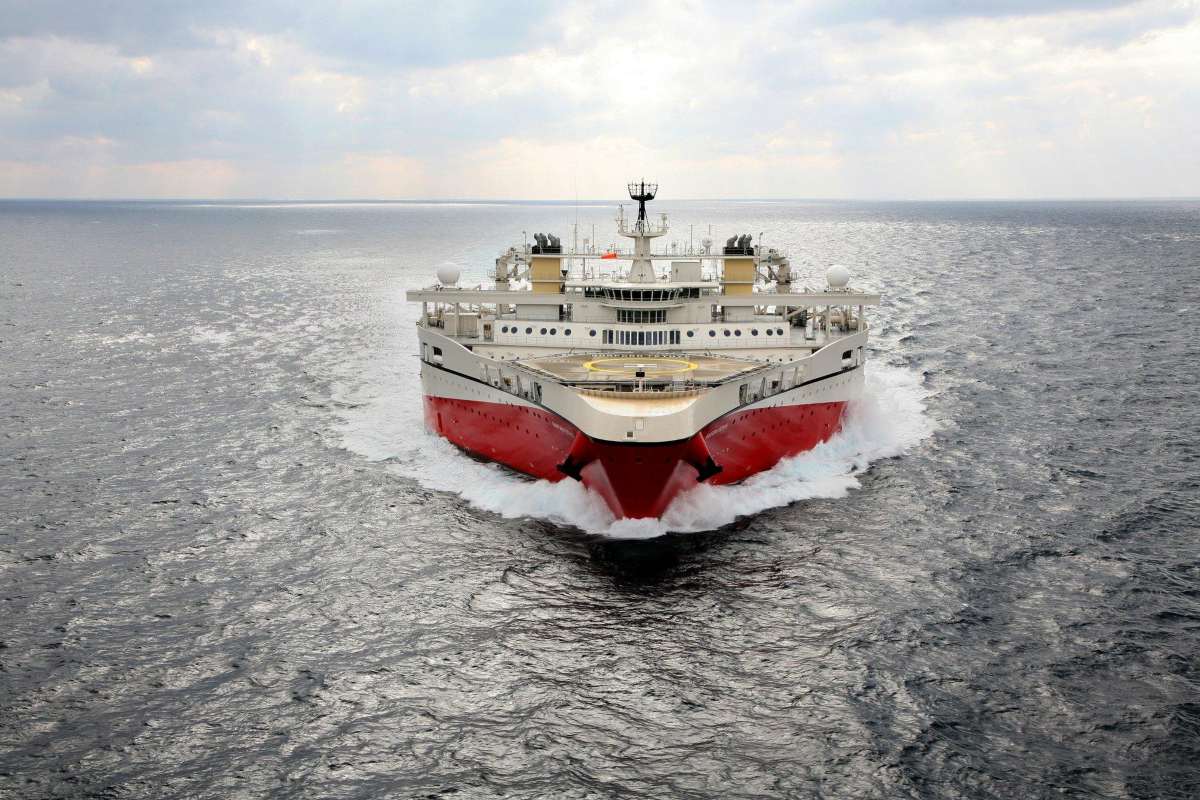
RAMFORM TETHYS: The Specialised Vessel Leading the Operation
The central vessel in the survey programme is RAMFORM TETHYS, a specialised seismic research ship designed for offshore geophysical investigations.
Seismic surveys are among the most important early stages of hydrocarbon exploration.
They help scientists examine geological structures beneath the seabed and identify formations that may warrant further investigation.
During the process, seismic signals are generated and their reflections recorded to build an image of subsurface geological layers.
The collected information can help geologists identify structures potentially capable of trapping hydrocarbons.
However, the presence of promising geological formations does not automatically mean that commercially recoverable oil or natural gas exists.
That can only be established through further technical evaluation and, where justified and authorised, exploratory drilling.
For Chevron and HELLENiQ Energy, the immediate objective is therefore to obtain reliable geological data.
Two Escort Vessels and Strict Maritime Safety Measures
RAMFORM TETHYS will operate with the support of two additional vessels.
The NAVTEX identifies THOR FREYJA, sailing under the flag of the Faroe Islands, and EDT NIOVI, sailing under the flag of Liberia.
The vessels will support the survey operation and help maintain safety around the research equipment.
One of the most important operational details concerns the length of the seismic cables deployed behind RAMFORM TETHYS.
The official notice states:
“LENGTH OF SURVEY CABLES OVER 6NM.”
This means the vessel will tow survey cables extending more than six nautical miles.
The cable ends will be marked by yellow tail buoys equipped with flashing lights and Automatic Identification System markers.
The NAVTEX also specifies the safety distances that other vessels must maintain.
These restrictions are designed to prevent dangerous approaches by other vessels and protect the extensive equipment used during the operation.
The maritime warning is scheduled to expire on January 7, 2027, unless replaced or amended by a subsequent notice.
Chevron–HELLENiQ Energy: The A2 and South Peloponnese Offshore Blocks
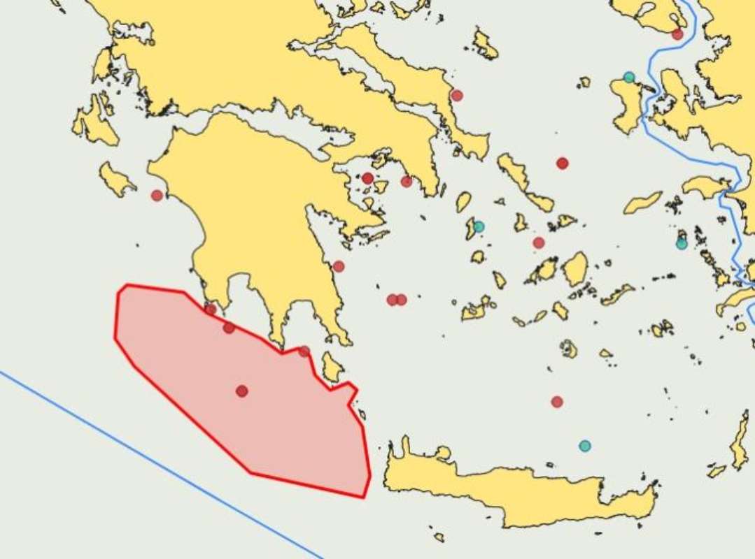
The seismic research programme concerns two offshore areas.
The first is Block A2, covering approximately 826 square kilometres.
The second is the South Peloponnese block, extending across approximately 11,000 square kilometres.
Both are associated with the offshore exploration activities of Chevron and HELLENiQ Energy.
Chevron is a major international energy company with extensive experience in hydrocarbon exploration and production.
HELLENiQ Energy is one of Greece’s leading energy groups, with activities spanning refining, energy trading and other segments of the energy sector.
Their cooperation forms part of efforts to evaluate the geological potential of offshore areas south of the Peloponnese.
The new seismic programme is an important stage in that process.
The information gathered will help determine whether particular geological structures justify more detailed investigation.
Future decisions will depend on the technical results, commercial considerations and applicable regulatory requirements.
More Than 14,000 Square Kilometres of Offshore Exploration Areas
The two blocks are geographically associated with Block 10, located in the Kyparissia Gulf and covering approximately 2,376 square kilometres.
Together, the three areas represent more than 14,000 square kilometres of offshore exploration acreage.
The combined size illustrates the geographical scale of offshore hydrocarbon exploration interest in western and southern Greece.
However, the total acreage should not be confused with the exact area to be surveyed during the current operation.
The NAVTEX defines the operational boundaries of the seismic campaign rather than the entire scope of potential future exploration.
The resulting geological data will require extensive processing and interpretation.
Only after that analysis can companies determine whether further exploration is justified.
What the Seismic Surveys Mean for Greece’s Natural Gas Prospects
The start of seismic operations represents a concrete step in assessing Greece’s offshore hydrocarbon potential.
It does not mean that a natural gas field has been discovered.
Instead, it allows scientists and energy companies to improve their understanding of geological formations beneath the seabed.
Greece has long considered the possibility of domestic natural gas resources in offshore areas that remain relatively underexplored.
Any future discovery would need to be assessed against several factors, including the size and characteristics of the resource, development costs, environmental requirements and market conditions.
Commercial production would also require additional investment, permits and infrastructure.
The distinction between exploration and production is essential.
Seismic surveys provide information.
Exploratory drilling, if undertaken, provides more direct evidence about the presence and characteristics of hydrocarbons.
Commercial development would come only after further technical and economic assessments.
For now, the priority is to establish whether the geological potential justifies the next stage.
A Second NAVTEX for the Corinth–Kos Electricity Interconnection
Alongside the hydrocarbon surveys, the Hellenic Navy Hydrographic Service has issued another NAVTEX covering geophysical research in the southern Aegean.
The operation concerns the Corinth–Kos electricity interconnection, part of the broader programme to connect the Dodecanese islands to mainland Greece’s electricity transmission system.
The vessels involved are NG SURVEYOR and OSV IEVOLI RELUME.
The surveys were scheduled to begin on November 18.
These investigations are different from hydrocarbon seismic exploration.
Their purpose is to examine seabed conditions and collect information needed to design a safe and technically suitable route for submarine electricity cables.
Geophysical surveys can identify seabed features, geological obstacles and other factors that may affect cable installation.
The findings are essential for engineering studies and route selection.
The separate NAVTEX informs maritime traffic of the research vessels’ presence and the operational requirements associated with their work.
Why the Dodecanese Electricity Interconnection Matters
Connecting the Dodecanese islands to the mainland electricity system is a major infrastructure objective for Greece.
Several islands currently rely on local power generation facilities, many of which use imported fuels.
Mainland interconnections can reduce dependence on these conventional generating units and improve electricity supply reliability.
They can also support the integration of renewable energy.
The Corinth–Kos connection is a key element of the broader plan.
The project requires extensive technical preparation because submarine electricity cables must be installed across complex marine environments.
Detailed seabed mapping helps engineers select suitable routes and assess installation risks.
The preparation process may involve geophysical surveys, environmental assessments and other technical studies.
Once completed, the wider interconnection programme is expected to strengthen the integration of the islands into Greece’s electricity system.
The scale and timing of those benefits will depend on the successful delivery of the relevant infrastructure.
Two Different Projects, One Broader Energy Infrastructure Agenda
The simultaneous issuance of the two NAVTEX notices highlights the range of offshore energy activities taking place in Greek waters.
South of the Peloponnese, seismic surveys are being conducted to assess possible hydrocarbon-bearing geological structures.
In the southern Aegean, geophysical investigations are preparing the ground for an electricity transmission project.
The operations have different technical objectives, different equipment and separate implementation processes.
Yet both require detailed knowledge of the marine environment and coordination with maritime authorities.
Both also demonstrate how offshore research supports energy-sector decisions.
In hydrocarbon exploration, geological data informs decisions about whether further investigation is warranted.
In electricity infrastructure, seabed data helps determine how submarine cables can be installed safely and effectively.
The distinction matters because neither NAVTEX, on its own, confirms that the relevant long-term project has reached its final development stage.
The Next Steps for Chevron, HELLENiQ Energy and Greece’s Island Interconnections
The RAMFORM TETHYS seismic campaign is scheduled to continue until January 7, 2027.
Once the fieldwork is completed, the collected data will undergo processing and geological interpretation.
The results will help determine whether further exploration should be considered in the offshore concession areas.
For Chevron and HELLENiQ Energy, the key question will be whether the surveys reveal structures with sufficient geological potential to justify additional investment.
Meanwhile, the geophysical investigations for the Corinth–Kos electricity interconnection will provide information needed for engineering and route-planning decisions.
The two NAVTEX notices mark the beginning of specific offshore operations in two important areas of Greece’s energy sector: hydrocarbon exploration and electricity network development.
One programme is assessing the potential of the seabed south of the Peloponnese.
The other is preparing a major infrastructure connection between mainland Greece and the Dodecanese.
The coming weeks will be important for the collection of seismic and geophysical data, while the longer-term significance of both projects will depend on the technical findings and subsequent investment decisions.
Source: pagenews.gr
Διαβάστε όλες τις τελευταίες Ειδήσεις από την Ελλάδα και τον Κόσμο